Herbaceous species richness along a topographical gradient in Steele Creek Park
by Anna Hess
When I was in high school, I sold t-shirts to help save the tropical rainforests. More recently, I opened an issue of National Geographic in which the cover article was on biodiversity. The article took us to places such as Australia, Costa Rica, Panama, and Hawaii. This fascination of ecologists and conservationists with the tropics in general and with the tropical rainforests in particular is not surprising. The tropical rainforests are the center of the world's biodiversity, meaning that more species can be found there than anywhere else on earth. Furthermore, the rainforests are being deforested so rapidly that scientists predict many species become extinct before they are even named by science. However, most people don't consider threatened centers of biodiversity closer to home.
I conducted my study in Steele Creek Park, in Bristol, Tennessee. Steele Creek Park is in the Ridge and Valley province of the southern Appalachian mountains. Due to the elevation, the range of temperatures in Steele Creek Park is very similar to that found at Swarthmore, College. The main difference is precipitation - you've probably heard of the Smoky Mountains, which are close to Steele Creek Park and which were named for the mist which clings to the hillsides due to the high humidity and large amounts of precipitation. The yearly rainfall in Steele Creek Park is similar to that in the Smoky Mountains.
The southern Appalachians is a very special place because it has a huge amount of biodiversity. Not as much as you would find in the tropics, but it has trophies all its own. You may have heard that the southern Appalachians is the world's center of salamander biodiversity, with more species of salamanders found there than anywhere else in the world. In the plant world, which is what I studied, the area has unrivalled shows of early spring ephemerals, the wildflowers which come up before the leaves come out on the trees. A few of the spring ephemerals can be found outside of the Appalachians - for example, you can find Bloodroot blooming in the Crum in the early spring - but many of the flowers are found only in the Appalachians. Walking in the Steele Creek Park in the spring, you can see extraordinary shows of literally dozens of wildflower species.
The tremendous biodiversity in the southern Appalachians is not limited to early spring wildflowers. In fact, most other types of herbs are similarly diverse in the region. Herbs, or herbaceous species, include any plants without a woody stem. They make up most of the species which you will find on the forest floor and all of the species which I studied last summer.
Now you may have noticed that I called Steele Creek Park a threatened center of biodiversity. Steele Creek was clearcut in the 1940s, as was most of the rest of the southern Appalachians. Luckily for us, Steele Creek then became a park and has been allowed to mature. The rest of the area has also been allowed to mature, but its owners are simply waiting until it is mature enough to be cut down again. To a forester, a forest is mature when the trees are large enough for it to be economically profitable to cut them down. Trees reach this age after about 50 years. So, if you do the math, the area was logged in the 1940s - 50 years later is the 1990s. And sure enough, there is currently a tremendous spate of logging occurring in the southern Appalachians.
So you may be wondering - if a forest is mature after 50 years, why does it matter if it is cut down as long as it is then allowed to regrow? Well, foresters and ecologists have a slightly different definition of mature. To a forester, when a tree begins to twist and bend or to develop heartrot, it is past its prime. Twisting and bending decreasing the amount of boards which can be cut from a tree. Heartrot is a natural mechanism which mature trees use to regain the nutrients in the center of their trunks by allowing the central dead wood to rot. It does not mean that the tree is getting old and likely to die, merely that it has reached a certain level of maturity. However, to a forester, a tree with heartrot is not very useful, because the hole in the middle prevents maximum usage of the wood.
On the other hand, ecologists are interested in the whole forest, not merely in the trees. A tree with heartrot is indispensable to the ecosystem since bears require large hollow trees in order to hibernate, and flying squirrels and bats will roost in hollow trees throughout the year. I was more interested in the herbs on the forest floor, but these species are also influenced by the age of the forest around them. Some herbs, such as Crested Dwarf Iris, can only live in an area in which the trees have been in place long enough to drop enough leaves to create the thick, dark, moist soil found in older forests. Other species, such as the Carolina Lily, require a mature forest before they can colonize an area and also must reach a certain age before they will bloom. Typically a Carolina Lily has to be 5-8 years old before it will begin to bloom. So it would take a long time to build up a population of Carolina Lilies.
Now, conservationists realize that the southern Appalachians are an important area and in need of protection. However, they can't simply go out and buy up all of the southern Appalachians. Instead, they have to set priorities and choose areas which are most important to be protected. Conservationists go about choosing areas to be protected in a variety of ways. Sometimes, they choose species, such as the Carolina Lily, which are particularly threatened and simply protect that species. A more holistic approach is to protect the habitat in which the threatened species lives. This approach is especially useful if the habitat is a very biodiverse area, so that many species are being protected at once. So, any study which gauges the biodiversity of an area can be useful to conservationists in assessing which areas should be protected.
I decided to explore the trends in diversity of herbs along a topographical gradient in the southern Appalachians. On a hillside, I divided the topography into four terrain types. The ridge is the area at the crest of a hill which typically has a shallow slope. The cove has a similarly shallow slope but is in the region between two hills. The top and bottom thirds of the slope were called the upper and lower slopes.
This division of the area into terrain types is not an arbitrary distinction. When you go out in the woods in Steele Creek, these areas look very different. The coves are a lush, green place. However, as you make your way up the hillside toward the ridge, the ground becomes barer until the ridge has very little understory growth. I hypothesized that this lack of growth on the ridge would also be linked to a lack of diversity. Furthermore, if the coves are more biodiverse than the ridges and if the reason for this difference in biodiversity can be determined, we might be given an insight into the reason that the southern Appalachians as a whole are so biodiverse.
In order to study the trends of biodiversity, I randomly located 38 plots within the park. In the field, I located the center of a plot, drove in a marker, and measured an 11 meter radius to define the outside edges of the circular plot.
Within each plot, I randomly located six quadrats. A quadrat is a square which measures 1 meter on each side. You simply lay the quadrat on the ground and look at the plants within it. The first thing I did was count the number of species of herbs in the quadrat. The number of herbs in the entire plot was called the herbaceous species richness. Next, I estimated the herbaceous percent cover in the quadrat. The percent cover is very simply - it is merely the percent of the quadrat which is covered by herbs. Finally, I dug a soil pit and measured the depth of the soil in each quadrat.
Figure 1 shows the number of average number of species found in each terrain type. You can see that the trend is exactly what I had expected - the species richness is greatest in the coves, least on the ridges, and at an intermediate value on lower and upper slopes.
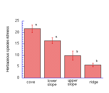
Figure 1: Herbaceous species richness versus terrain type. ANOVA showed a statistically significant difference in the herbaceous species richness per plot at different terrain types (p<0.0001). Letters refer to statistically significantly different means (using Tukey/Kramer post hoc, p<0.05). Error bars indicate standard error.
However, there is a problem with this result. This graph tells me that if I went out and looked at circular plots with an 11 meter radius in coves and on ridges, the plots in the coves would have more species. However, what I really wanted to know was, if I had unlimited time and resources and could count every single plant in the coves and every single plant on the ridges, would the coves have more species than the ridges?
Scientists never have unlimited time and resources, but they've developed a way to get around this problem, and the way is called a species-area curve (Figure 2). Each line represents a different terrain type and each point represents a plot I surveyed in the terrain type. The order of the points on the line shows the order in which I considered the plots to make this species-area curve.
The y-axis is a little bit more complicated. It represents a value somewhat like the species richness, but over a larger scale. Each point represents the cumulative number of unique species found in the plot being considered and in each plot previously considered. So, for example, if the first plot had species A, B, and C in it, it has three unique species. However, if the second plot has species B, E, and F in it, then species B was already found in the first plot, so there are only two unique species in the second plot. The cumulative number of species for the second plot is the number of species found in the first plot plus the number of species found in the second plot - five. So the y-value of the final point on the species-area curve refers to the total number of unique species found within every plot in the terrain type.
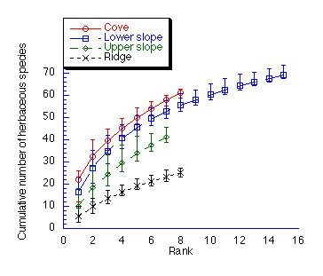
Figure 2: Each curve represents 1000 random rearrangements of the order of the plots. The mean and 95% confidence intervals are plotted.
So, to return to the data in Figure 2, you can see that, ignoring the end of the lower slope curve for a moment since I sampled more plots in the lower slope than in any other terrain type, the coves have the most species, then the lower slopes, then the upper slopes, then the ridges. This is the same trend we saw in species richness per plot.
However, there is still a problem with the data. We are not meant to just look at the height of the last point in a species-area curve, or we wouldn't plot the whole curve. Instead, we also need to look at the shape of the curve. A scientist wants a species area curve to level off which means that it comes up to a certain height, then becomes flat and goes along perpendicular to the x-axis forever. Now, you know that every time the curve rises, that means that in the next plot, I found a species which I had not previously found in that terrain type. So, if the curves level off, it means that I could keep surveying more plots and never find new species, which means that I sampled a large enough area to get an indication of how many species are out there overall.
As you can see, none of my curves levelled off. That finding is fascinating, actually, because these curves represent 108 species. Since the curves do not level off, that means that there are yet more species out there, attesting to the tremendous biodiversity of the area. However, it also means that I need to do another study sampling more plots before I can conclusively prove that coves have more species than ridges. However, for now, we will assume that these trends are correct and that coves are the most biodiverse area in the park.
So the obvious conclusion is that the coves, this tremendously biodiverse area, need protection, while the ridges are less important to protect. However, to say that the ridges do not need protection, we need to look at the species which live on the ridges. Both Pink Lady's Slipper and Teaberry, among other species, are only found on ridges and upper slopes in Steele Creek. So, if we only protected coves, neither of these species would be protected. In fact, Pink Lady's Slipper is a Rare Plant in the state of Tennessee, meaning that it is rare enough that it needs protection from the state.
I found four plants in Steele Creek Park which are on the Tennessee Rare Plant list.
Two of these plants, Ginseng and Mountain Honeysuckle, are generalists, while Pink Lady's Slipper is a ridge specialist and Butternut, a tree, is a cove specialist. Therefore, we can't merely protect one area and expect to maintain the biodiversity of the southern Appalachians. Both the coves and the ridges need to be protected.
Now everything I've shown you up until this point has been strongly supported by my data, but I want to go on and explore some of the things which might have caused this difference in biodiversity between the coves and ridges. My data is slightly less conclusive for this part, so further experiments are needed before we can conclude that what I am going to tell you is definitely true.
Before I go on to those causes, I have to give you a little bit of vocabulary. A resource is anything which a plant needs to grow and live - so water, sunlight, and soil nutrients are resources. A limiting resource is the resource which is in such short supply that the plant can only grow as quickly as it can acquire the resource. So, imagine for a moment that you cleared a bare patch of earth in the middle of your lawn. You planted a seed there and watered it every day. The seedling will come up and it has all of the sunlight and all of the water that it needs. However, you haven't fertilized your lawn in years, so there isn't much nitrogen in the soil and the plant can only grow as quickly as it can suck up nitrogen. In that case, nitrogen is the limiting resource.
On the other hand, let's say you cleared this bare patch of earth under a tree in your yard and planted a seed. This time, you got smart and put some compost in the soil, so the seedling had plenty of soil nutrients. You also watered it every day, so it had plenty of water. However, the seedling is in the shade of the tree, so it doesn't get much light, and it can only grow as quickly as it can soak up light. So light is the limiting resource.
Now, ecological theory says that for an area with one limiting resource, only the plant which is best able to compete for that resource can grow there. This may sound a little strange, because basically what I'm saying is that an area should be covered by one species. But, if you've ever been to the south, imagine a field completely covered by kudzu. That's what I mean - that the one species best able to compete will take over.
So imagine that in your bare patch of earth under the tree, you planted two seeds of two different species rather than one. Both seedlings come up and they're both competing for sunlight. One species has big leaves which it can quickly put out and overshadow the other species. The poor, overshadowed species will eventually die from lack of sunlight and the other species will take over the area since it was best at competing for the light.
You may be wondering - how does this idea that there will be only one plant in an area explain the tremendous number of species found in the southern Appalachians? Well, to increase the number of species which grow in an area, you have to increase the heterogeneity.
I gave you an example of a time when one species is the best competitor and thus takes over an area. However, let's say that your yard was not completely flat. Instead, it had pits and mounds. Now, on top of the mounds, the sun beats down on the ground and dries up the soil, so only species which are good at competing for water can grow there. However, down in the pits, the soil is shaded by the mounds and less water evaporates away. Therefore, species which aren't good competitors for moisture but which are good competitors for something else, such as soil nutrients, can grow there. Therefore, by having two slightly different habitats, two species can grow there rather than just one.
Every time another type of heterogeneity is introduced, the number of species living there can increase. There are many types of heterogeneity, and I'll just give you another couple of examples. Soil can be rich or poor, and areas can be in the sun or in the shade.
The obvious type of heterogeneity in the southern Appalachians is elevation. If one species is best able to grow at the crest of a ridge, another a little further down, and so forth, than many species can grow on the mountain, separated along the topographical gradient. Studies have shown that herbs specialize to specific elevations on tall mountains in the southern Appalachians. Furthermore, trees in Steele Creek Park specialize to different terrain types. There are two different tree communities found in the park.
The ridges contain the oak-hickory community which, as you may have guessed, contains oaks and hickories. The area also used to contain American Chestnut before a blight wiped out virtually all of the adults in the middle of the 1900s. Now, we find only small Chestnut trees in the park, such as this one which shot up from the roots of an older tree.
The coves contain the cove hardwood community, which is a very diverse tree community containing dozens of species, including trees which you might know such as Tulip-tree, White Ash, and Basswood. The slopes contain a gradient between the oak-hickory and the cove hardwood communities.
So, if trees specialize to terrain types in Steele Creek, we might expect herbs to specialize as well. However, very few species were found only in coves and not in ridges or vice versa. This lack of specialization is not as surprising as it seems since, as you may remember, Steele Creek is in the Ridge and Valley province, so the hills are not too high. The change in elevation between the lowest cove and the highest ridge is merely 900 feet.
Another potential cause of heterogeneity is treefall gaps. When a tree becomes old, or when ice or snow on its branches make it top heavy, it often falls over and creates a gap in the canopy such as this called a treefall gap. Sun shines down through this gap and allows species to grow on the forest floor which could not grow under a closed canopy in the forest. Forest species usually have to be good competitors for light, because light is a very important limiting resource in the forest. However, species which are not good competitors for light can grow in the gaps. These species are called early successional species. You may have never heard the name, but I'm sure you have seen the species, since they also grow in old fields. Early successional species include species such as Milkweed, Poke, and Butterflyweed.
Now, I didn't mention earlier that the two forest types found in Steele Creek Park do not differ merely in the species which make them up - they also differ to some extent in the dynamics of the forest. When a tree dies in the cove hardwood community, it tends to fall and create a treefall gap. However, when a tree dies in the oak-hickory community, it remains standing. When a tree dies and remains standing, the branches on either side of it quickly fill up the gap and no treefall gap forms. This was seen in my study in which a quarter of my cove plots contained recent treefall gaps and none of the ridge plots contained treefall gaps. You can also see this by just going for a walk in the woods. Fallen trees lay across the cove while most dead trees on ridges are standing. Therefore, a potential cause of the greater species richness in coves is the addition of early successional species which are unable to grow on ridges due to the lack of treefall gaps.
If the greater species richness in coves is merely due to the addition of early successional species found in treefall gaps, then we would expect that if we only looked at plots with no recent treefall gaps, coves and ridges would have the same number of species. The species-area curve in Figure 3 only includes plots without recent treefall gaps and you can see that, contrary to our predictions, we see the same trend we saw in our other species area curves - coves are the most species rich, then lower slopes, then upper slopes, then ridges. So, although treefall gaps probably increase the biodiversity of the southern Appalachians as a whole, they do not explain the differences in diversity between coves and ridges in Steele Creek Park.
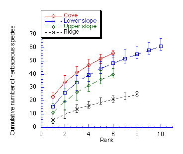
Figure 3: Species-area curves excluding plots which contained recent treefall gaps. Each curve either represents all of the possible arrangements of the order of the plots or 1000 random rearrangements. The mean and 95% confidence intervals are plotted.
Now, you may remember from the very beginning that I said that coves were very lush and green while ridges were a somewhat barren place. Figure 4, which is the average herbaceous percent cover for each terrain type, shows this trend. You'll remember that percent cover is merely the percent of the quadrat which is covered by herbs. Percent cover is an indication of productivity - if more of the quadrat is covered by plants, the area is more productive. You see that coves have a huge average percent cover - about 63%, while less than 10% of the average ridge quadrat is covered by herbs.
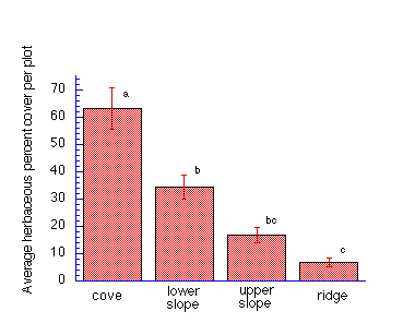
Figure 4: Herbaceous percent cover versus terrain type. ANOVA showed a statistically significant difference in the herbaceous percent cover per plot at different terrain types (p<0.0001). Letters refer to statistically significantly different means (using Tukey/Kramer post hoc, p<0.05). Error bars indicate standard error.
Figure 5 shows that cover was closely correlated with species richness. Plots with more plant cover tended to have more species while plots with less plant cover tended to have fewer species. This suggests that the greater productivity in coves may be the cause of the greater diversity there.
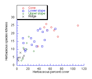
Figure 5: Herbaceous species richness versus herbaceous percent cover. Cover has a statistically significant effect on richness (ANCOVA; p=0.0272). ANCOVA showed no statistically significant interaction (p=0.529) between cover and terrain, so cover has the same effect on species richness at all terrain types.
The greater productivity in the coves may be a result of the soil. Figure 6 shows the depth of the Oe and A horizons, which contain the dark, fluffy part of the soil found immediately under the leaf litter. You can see that these horizons were deepest in coves, suggesting that there were more soil nutrients available for plants in the area. On a more obvious level, coves often have creeks. Even coves without creeks tend to have moister soil than ridges. So, the combination of deep soil and plenty of moisture may be the factor which allows the coves to be so productive.
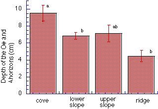
Figure 6: The depth of the Oe and A horizons versus terrain type. ANOVA showed a statistically significant difference in the depth of the horizons at different terrain types (p=0.0005). Letters refer to statistically significantly different means (using Tukey/Kramer post hoc, p<0.05). Error bars indicate standard error.
Another scientist, David Tilman, has shown a similar relationship between productivity and richness in grasslands. However, the relationship is not well understood in forests. My guess, which is backed up only by pictures from an old growth forest near Steele Creek, needs to be tested.
While walking in the old growth forest, I found that ridges were not the barren place seen in Steele Creek. They were covered with plant growth, and included species found only in coves in Steele Creek, such as this Black Cohosh. Other species, such as Jewelweed, which you can find beside creeks in the Crum or in coves in Steele Creek, were also found on the ridge in the old growth forest. This suggests that species found only in coves in Steele Creek may not actually be cove specialists. These species may simply need the thick, protective soil or other old growth characteristics, such as a pitted forest floor which develops from rotting, fallen trees. If this is the case, then these species may grow in coves in Steele Creek because of the productivity of coves, which allows the trees to grow more quickly and drop more leaves. Over time, the coves may mature more quickly than the ridges, allowing old growth specialists to grow in these areas.
So, my conclusions are quite simple. Trends in herbaceous biodiversity follow the topographical gradient in Steele Creek Park, with the coves being the most species rich and the ridges being the least species rich. Productivity is the factor most closely linked to biodiversity, with the more productive coves having a greater species richness. This productivity could possibly increase biodiversity by allowing the forest to mature more quickly and regain old growth characteristics.